Digikam/Geotagging
Geotag dine fotos med Open GPS Tracker og digiKam
Fra Dmitri Popovs blog, 16, februar 2011
Du behøver ikke et avanceret kamera med indbygget GPS-modtager for at geotagge dine fotos. En Android-enhed med programmet Open GPS Tracker og digiKam fungerer fint. Programmet lader dig følge din rute og gemme den som en GPX-fil, som du derefter kan bruge til at geokorrelere dine fotos i digiKam.
Geokorrelation er en forholdsvis enken proces, som tildeler geografiske koordinater fra GPX-filen til dine fotos baseret på deres tidsangivelse. For at denne teknik skal fungere skal du altså først synkronisere tiden på din Android-enhed med dit kamera. Når du går ud for at tage billeder, så starter du Open GPS Tracker på din Android-enhed og starter en ny sporingssession. Når du er kommet hjem igen, stopper du sporingssessionen og bruger knappen i Open GPS Tracker for at gemme det optagne spor i GPX-format på SD-kortet eller sende det med en e-mail til din maskine.

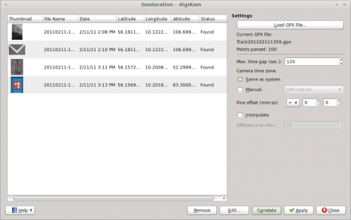
Offload then the photos from your camera to digiKam, select them, and choose . Press the button and select the GPX file. digiKam should then automatically assign geographical coordinates to the photos. By default, digiKam can tolerate a 30-second gap between the time settings of the camera and the GPX track. If the gap is longer, the application may fail to assign geographical coordinates to some of the photos. In this case, you can increase the time gap in the field. Press then the button to refresh the geographical coordinates. This makes geocorrelation less precise, but you can use the button to adjust the coordinates manually. Once you’re satisfied with the result, press the button to save the assigned coordinates in the photos’ metadata, and you are done.
