Marble/Tracking: Difference between revisions
Earthwings (talk | contribs) m (moved Marble/Maemo/GPSGuidelines to Marble/Tracking: Not Maemo specific) |
Earthwings (talk | contribs) (Remove routing traces, improve wiki markup) |
||
| Line 1: | Line 1: | ||
{{Warning|This page describes a version of Marble which has not yet been released (as of 07 Jan. 2011).}} | |||
In this tutorial you learn how to record a GPS track with Marble and share it with your friends. The track recording is based on the mobile version of Marble ([[Special:myLanguage/Marble/Maemo/Installation|Marble 1.0 for Nokia N900]]). You can also use the Desktop version of Marble, but you need a more recent version (Marble 1.1 or later) and a GPS device. | |||
== GPS Tracking == | |||
The internal GPS of the N900 is used to retrieve your current location. The track is shown in the map and can be saved for further analysis in other programs. | |||
Enable GPS on the N900 in Marble using the GPS button (second button from the left of the four large buttons on the bottom of the screen). Once enough satellites are in view, Marble shows your current position on the screen. | |||
[[File:MarbleMaemo-Tracking01-EnableGPS.png|400px|center]] | |||
[[File:MarbleMaemo- | |||
''' | {{Tip|If the current location is not visible on the screen, you can move to it using the '''Go To...''' menu: Click anywhere on the map and choose '''Go To...'''. In the upcoming dialog, select '''Current Location'''.}} | ||
== Track Recording == | |||
Whenever you like, you can save your track in the '''Tracking''' dialog. [[File:400px-MarbleMaemo-Tracking03-TrackingDialog.png|400px|center]] | |||
[[File:400px-MarbleMaemo-Tracking03-TrackingDialog.png|400px|center]] | |||
This track can be saved in [http://en.wikipedia.org/wiki/Keyhole_Markup_Language '''kml'''] format and can be used for further reference. | This track can be saved in [http://en.wikipedia.org/wiki/Keyhole_Markup_Language '''kml'''] format and can be used for further reference. | ||
[[File:MarbleMaemo-Tracking04-TrackingSave.png|400px|center]] | [[File:MarbleMaemo-Tracking04-TrackingSave.png|400px|center]] | ||
== Sharing Tracks == | |||
It's very convenient that this kml file can be viewed on your Desktop. | It's very convenient that this kml file can be viewed on your Desktop. | ||
| Line 36: | Line 28: | ||
Using a command line interface converting from '''KML file format to [http://en.wikipedia.org/wiki/GPX '''GPX'''] file format''' is very easy. | Using a command line interface converting from '''KML file format to [http://en.wikipedia.org/wiki/GPX '''GPX'''] file format''' is very easy. | ||
gpsbabel -i kml -f input.kml -o gpx -f output.gpx | |||
where input and output are files in kml and gpx respectively. | where input and output are files in kml and gpx respectively. | ||
Revision as of 08:55, 7 January 2011
In this tutorial you learn how to record a GPS track with Marble and share it with your friends. The track recording is based on the mobile version of Marble (Marble 1.0 for Nokia N900). You can also use the Desktop version of Marble, but you need a more recent version (Marble 1.1 or later) and a GPS device.
GPS Tracking
The internal GPS of the N900 is used to retrieve your current location. The track is shown in the map and can be saved for further analysis in other programs.
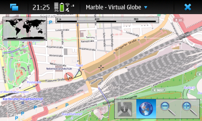
Enable GPS on the N900 in Marble using the GPS button (second button from the left of the four large buttons on the bottom of the screen). Once enough satellites are in view, Marble shows your current position on the screen.
Track Recording
Whenever you like, you can save your track in the Tracking dialog.
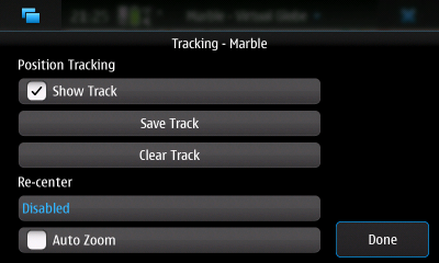
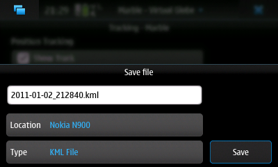
This track can be saved in kml format and can be used for further reference.
Sharing Tracks
It's very convenient that this kml file can be viewed on your Desktop. Prerequisite: Here you must be having Marble installed on your Desktop.
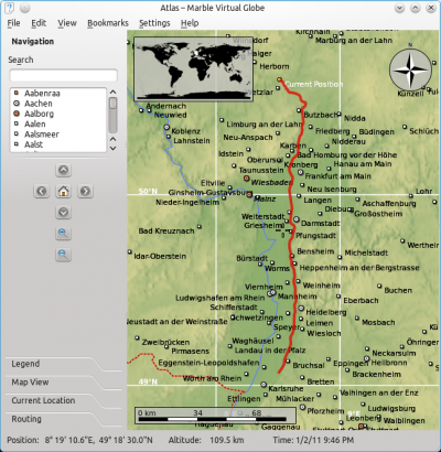
Using a command line interface converting from KML file format to GPX file format is very easy.
gpsbabel -i kml -f input.kml -o gpx -f output.gpx
where input and output are files in kml and gpx respectively.
Both Kml and gpx specify a set of features (like maps,images)that can be used by Marble, Google Earth and same kind of applications. These are standard formats. Kml is originally developed for being used with Google Earth but Now-a-days Marble is also providing support for it. GPX on the other hand is widely accepted by all the applications.
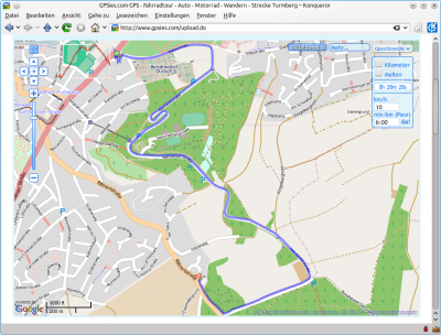
It is also much of use as we can share our kml/gpx tracks with friends and communities just by uploading them on gpsies.com like shown below.
