Jump to content

Translations:KGeography/Making Maps/20/uk: Difference between revisions

From KDE UserBase Wiki
Yurchor (talk | contribs)
Created page with ";Чи можливе створення неполітичних карт? :Так, концепцію об’єктів на карті можна поширити на річ..."
(No difference)

Revision as of 11:53, 11 March 2011

Information about message (contribute)
This message has no documentation. If you know where or how this message is used, you can help other translators by adding documentation to this message.
Message definition (KGeography/Making Maps)
;Is it possible to do non-political maps?
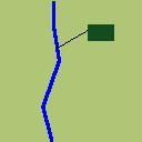
:Of course, the division concept can be extended to a river or a mountain. In the making of the map you should keep in mind that most times the river or mountain will be too small that you should provide an additional clicking area.
:In this example the river would have the dark green area and color <20,76,34> as its identifier.
[[File:River.png]]
Чи можливе створення неполітичних карт?
Так, концепцію об’єктів на карті можна поширити на річкові системи або гірські масиви. Під час створення таких карт слід мати на увазі, що на картах річки та гори є доволі малими об’єктами, тому варто трохи збільшити їх розміри або створити спеціальні ділянки для натискання.
У нашому прикладі річка буде малинового кольору (компоненти <20,76,34>).