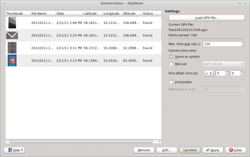
Digikam/Etiqueta geogràfica
Fotos amb etiqueta geogràfica amb Open GPS Tracker i digiKam
Transcrit des de l'article d'en Dmitri Popov, el 16 de febrer de 2011
No necessiteu cap càmera amb un receptor de GPS incorporat per geolocalitzar les vostres fotos. Un dispositiu Android amb l'aplicació Open GPS Tracker i digiKam pot fer la feina molt bé. L'aplicació us permet realitzar un seguiment de la vostra ruta i la desa com un fitxer GPX que després podreu utilitzar per correlacionar geogràficament les vostres fotos a digiKam.
La correlació geogràfica és un procés relativament senzill que assigna les coordenades geogràfiques des del fitxer GPX a les fotos en base a les marques de la seva hora. Per a que aquesta tècnica faci la seva màgia, haureu de sincronitzar l'hora al dispositiu Android amb la de la càmera. Quan aneu a prendre fotos, llanceu el Open GPS Tracker al dispositiu Android i inicieu una nova sessió de seguiment. Quan torneu a casa, atureu la sessió de seguiment, i utilitzeu el botó en el Open GPS Tracker per desar la pista gravada en el format GPX a la targeta SD o enviar-la per correu electrònic a la vostra màquina.

Offload then the photos from your camera to digiKam, select them, and choose . Press the button and select the GPX file. digiKam should then automatically assign geographical coordinates to the photos. By default, digiKam can tolerate a 30-second gap between the time settings of the camera and the GPX track. If the gap is longer, the application may fail to assign geographical coordinates to some of the photos. In this case, you can increase the time gap in the field. Press then the button to refresh the geographical coordinates. This makes geocorrelation less precise, but you can use the button to adjust the coordinates manually. Once you’re satisfied with the result, press the button to save the assigned coordinates in the photos’ metadata, and you are done.
